Sunday, July 19, 2009

Two Blondes and a Monkey

Who: Alison and Emily (with BRC BoeAlps)
What: Climbing Monkey Face in 4 pictches
Where: Smith Rock
When: (I think) July 19th, 2009

[awaiting pictures from Emily!]


On Saturday when Emily came back from her climbs with another student she asked me “Did Oscar tell you the plan?” Unaware of any plan, my curiosity was instantly peaked. “No…” I hesitated, a little excited, trying to hide my enthusiasm; any day worthy of a “plan” sounded enticing to me, especially if it was with (my new idol) Emily.

“Follow me” Emily beckoned and without hesitation I was a step behind headed to the car to unmask the elements required for the “plan” the following day.

When we got to the car Emily pulled out a pair of aiders (also called etrier’s) as she unveiled the plan of climbing Monkey Face the next day. This climb has one pitch (a section of rock that only requires one rope length) that required aiders, which I had never used. Aiders kind of look like ladders made of webbing (they ‘aid’ you up the rock face). This section of the climb is bolted, so you would hook the aider to a caribeaner and then hook that to the bolt, giving you an instant ladder. You’d have two ladders so while standing on one, you could reach the next bolt, clip in with the next ladder, shift weight onto the new ladder, and then unclip the old ladder from the lower bolt.

Emily scanned the area for a tree worthy of demonstration. The only reasonable tree happened to be in front of the crowed of classmates (this is while we were still waiting for some classmates to get back to the parking lot). Emily made two makeshift “bolts” in the tree (just caribeaners on varying lengths of cord). She showed me how to adjust the personal anchor that’s attached to the aider to assist in reaching the next bolt.

Then it was my turn to try. It was a little awkward climbing the tree, a rock face would be much wider, but I could at least get the idea of what was going on. Climb as high as you can on one ladder until you can reach the next bolt. Bolt your second ladder in, climb it until you can reach the next bolt, rinse and repeat.

Emily also mentioned the possibility of leading this pitch. The class specifically said that it did not cover leading, so I was surprised to hear of the lead potential. I told her it sounded awesome, but I’d give her a final answer the next day. At this time I’m not sure if the head instructor was aware of this part of the plan or not—it was surely his call first if it was going to be OK.

Sleeping at night was hard. I’m not sure if it was because of my excitement of the next days climb, or if it was just because it was super hot out (I’m assuming mainly the latter, but the former didn’t help). The night before had been rather cold, but this night I had my 30 degree bag unzipped and was still sweating.

While trying to sleep I went over how to use the aiders in my head and went through the calculated risk of leading this pitch. It seemed like there was basically no risk of falling. Not only would I be secured by the rope, but each aider had its own anchor to hold me on, the most that could happen is I loose my balance and swing into the wall, this is no worse than any other fall (in fact, it is probably better than falling anywhere else, because it is a completely vertical pitch so I wouldn’t be falling onto strange poking rocks). I decided if Emily/Oscar (the head instructor) said I could lead, I would love to take the opportunity to do so. Maybe they’d even let me lead a real pitch at Squamish (rock wall in BC) in a few weeks! (Don't worry Mom, leading for this part was basically the same as following).

When we got to the parking lot in the morning, after another French toast breakfast, Emily and I headed out for our destination before the other student/teacher partners were called out. We were on a mission. We talked excitedly about the climb during the 45 minute hike to the base. I went over different techniques/skills that I wanted to confirm the correct order of implementation.

Once we got to the base of the climb and were flaking out the rope (making sure there were no knots or tangles) another group of 2 came along. These boys were from Oklahoma and had just spent a month climbing all over the west. We quickly made friends and decided to climb together.

To get down there is a 60m rappel off the face, so you need two ropes. If we went by ourselves, we would have had to either carry one rope in our backpack, or lead with two ropes. Neither are fun options. We decided that we’d tie our rope with the guys’ rope to rappel down, allowing both parties to carry one rope a piece. Emily would still lead and I would follow cleaning her gear. Then one of the boys would lead the same pitch, and the second one would clean his gear.

One of the climbers had a lot of experience and led all the pitches. The other guy was a pretty good climber but he was definitely new to aiding as well.


The follower


The leader


The first pitch rated 5.8 had a tricky spot with little hands and virtually no feet. It was hard for Emily to protect the route well and a challenge for me to clean the route too. After that beginning section the rest of the pitch was pretty straightforward, going up and over flakes.

The second pitch had a nasty 5.8 chimney finger crack, by far the hardest part of the day. When I finisehd the pitch and met Emily at the belay station she told me “yea, but it had great feet” and my reply was “I couldn’t find one good foot, it was terrible.” Apparently I need a bit more practice. I was also carrying a backpack up the route (another first for me) and I think the backpack took on another added challenge level, especially in the chimney. I found some pretty good spots for my hands/fingers but with all my weight on them, I couldn’t hold the position very long.

While climbing that crack I wore out my arms quickly I asked to “take” (this means the belayer should take in all the slack on the rope) so I could rest for a moment. I was saddened as I was let down a few feet (ruining the progress on my last few moves). Emily’s new rope had a high elongation ratio and Emily moved to get in a better position to hold me, and while doing so, some more slack was necessary.

A bit disheveled, knowing the boys were watching me from below, I tried to get back to my old position a few steps higher, staring at the vertical face with no obvious feet and the small crack expected to help me progress. In retrospect, this silly finger chimney crack was actually overhanging a bit, no wonder it was hard!

Once I got to my old position I jammed my hips into the sloping chimney and held there for a moment--flailing with my feet. I felt like a newb, but eventually I got a good enough foot hold that I could move my body up. Hopefully I didn’t look too much like a wiggling worm.

Normally I’d try to squeeze my back into the chimney, but with the backpack on this wasn’t an option. I wasn’t really sure how to navigate.

Once I topped the chimney the holds for hands and feet increased exponentially and I was back to feeling good about myself. I thought ‘the next time I climb that, I’m going to do much better.’

Yes, there will be a next time.

Once I reached Emily at the belay station it was time to unpack the backpack. We pulled out the aiders and Emily once again suggested I lead. I was excited and nervous, even though leading this section was basically the same thing as following it.

I ran through the basic scheme of things, Emily approved, and encouraged me on. I started up the wall in what felt like the slowest pace ever. About 3 bolts in, I had made a small tangle with the rope and the ladders and my personal anchors. I had to ask for slack and unhook a few things to re-arrange.

I wasn’t about to let this mishap happen again. By this time it felt like the guys were already at the belay station (either they did really fast getting up that chimney, or I was really slow, or I just didn’t notice when they got there, but anybody watching makes you self-conscious).

I worked up the rest of the route as Emily shouted encouraging words and commented on my fast pace. I didn’t really believe her about the fast pace because I felt slow as a snail, but I had my routine that enabled my aiders to be clutter free and slowly made my way up the rock.

I kept hearing about how you had to “whale” yourself into the mouth of the monkey. I wasn’t really excited for this part, but soon was able to experience it. I didn’t think I had to “whale” too much, and although there were no handholds I felt like I was able to kick myself up with the aiders instead of beaching myself into the mouth.

I belayed Emily up and she was a speed daemon, I couldn’t believe it. When she got up I commented on her rocket speed and said there was no way I was fast at all. She claimed that she’s had a lot of practice and went on to tell a story of the first time a VERY experienced climber led this pitch and he was at least 2-3x slower than I was leading it. I felt like this would be a silly story to make up, so I went with it, and took the compliment, feeling a little better about myself, and less like I was holding the other dudes up. Emily said that the dude’s even commented on my speed up the wall. My conclusion: aid climbing is slow no matter what.

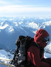
Soon we were ready for Emily to lead the last pitch up out of the mouth. This is the “most exposed 5.7 move in the world.” It looks like a “1500ft drop but is only 150ft.” I think I was more scared when Emily was leading then when I followed (though I’m not sure why, I was more than completely confident in her skills, maybe it was just because it was an awkward belay stance and if she did happen to fall it was going to be another adventure getting back up).

When it was my turn to get out of the mouth I stuck my head out to try and find the next hold. I wasn’t confident in where it was, and I hesitated for a what seemed like a few minutes, trying to gain confidence in just “going for it.” I went over the facts in my head: worst thing that could happen is I fall a few feet and have to prussic up the rope (due to rope stretch) to get back to the mouth. No biggie.

I felt lame for hesitating, especially when there were so many spectators watching (I swore somebody called out my name too). I felt like I wasn’t putting on a good show. For the spectators, if I fell, that’d be epic, or if I climbed it, that would be just as awesome (for them). When Emily climbed and got to the top, many of the tourists cheered and many took pictures with thier telescoping cameras.

It was really odd knowing that you were going to be in all these climbers photographs. We decided we were in at least 50 peoples shots (not to mention the guys with the super crazy telephoto lenses that you could hear constantly shooting). We should have shouted out our emails or held up a sign so they could email us the pictures!

Once we got to the top (wohoo!) we waited on the flat head (that strangely has no anchors/bolts) for over an hour while the two guys climbed the aid section and joined us at the top. When I left the mouth, the lead guy was in the mouth, but the second guy must have taken FOREVER to do the aid section. He apologized about the wait and said it was his first time using aiders (hey, it was mine too!).

Either way, it was super sunny weather and there was a slight breeze so it was rather enjoyable (the delay was just was going to make us get back a bit later). We took the boys photo’s (after asking them to take one of us) and then we all started the rappel. There is a very short rappel to the double rope rappel station where we tied our ropes together so we’d have enough rope for the 50/60m rappel.

This was my first real free rappel (free as in you’re not going down the wall/touching any rock, you’re just hanging in midair!). At one point Emily yelled up to tell me to do a leg wrap and then let go of the rope so I’d be freely suspended in the air. I’m pretty sure she got a picture of this too.


Emily walking home


By the time we walked back to our bags (less than 20 minutes from the rappel station) it was time to race back to the meeting spot. We hadn’t brought any lunch to the summit (opps in retrospect, but it would have made the bag heavier!), so we grabbed a quick bite and then skedaddled back. We were surprised to see almost nobody on the wall (especially nobody from our group—yesterday there were many groups over 2 hours late to the meeting spot). Perhaps since today was round two and it had been so hot out everybody decided to call it quits early (and to make up for their tardiness the day before!).

We were the last to arrive and everybody wanted to know how Monkey Face was. I claimed it was “totally friggin rad.”

Before making it back onto the highway we stopped at this tiny climbers shack where our carpool enjoyed a scoop each of mtn huckleberry and blackberry ice cream. Delicious!

Saturday, July 18, 2009

Bob Rocks, err, Smith Rocks

Who: BRC BoeAlps (namely, Bob B, Vermon, me!)
What: Rock Climbing! (Learning how to climb cracks)
Where: Smith Rocks, OR
When: July 18th, 2009


We woke up early to ensure we had enough time to grab a bite to eat at the local diner. Filled with French toast we were off to climb at Smith Rocks.

At the parking lot we were all assigned instructors. I was stoked when I found out that Bob B. would be my instructor (Vermon’s too). Bob B. is one of the intsructors who attended 2 of our climbs for the BCC class. He was obviously one of the more experienced climbers who helps out with the BoeAlps programs. The 2 weeks before this climb he had been up having a crazy time at Yosemite doing some really big wall climbs. His stories by far beat any i've ever written. Though I’m not sure if I’m jealous or not...

It was really fun to also note the interaction between instructors. Especially the youngish but more experienced ones. There was tons of playful banter; the better you can give it back, the more respect you earn. My kind of team!

Every group was assigned a starting area as well (to space us out on the rocks). As we walked to our assigned spot, Bob asked us about our skills. We admitted to not knowing anything about cracks, but we showed a lot of enthusiasm to learn. Bob decided that our wall would not be as fun for learning (for on the second pitch is when we really get into the crack section) and brought us a bit further down for some practice crack climbing.

Before getting on the wall Bob told us of the many methods for holding on such as fist jams, hand jams, and finger jams. He noted how some people use tape gloves (tape covering your fingers/back of your hand to prevent the rock from scraping it up) but wanted us to know that he didn’t use them. He claimed he didn’t feel tougher than others, but it was just his preference not to use them.


Climbing my first crack. Bob is belaying


I personally wanted to wait to use tape. I wanted to see what the cracks felt like first, because the tape is only going to lesson your feeling (perhaps in a good way!). All in all, after a day of climbing cracks, my hands were barely marred. For now I’ll be tape free.

After practicing crack methods we crossed to the other side of the wall to the Spiderman Buttress Area. Apparently this area is always SUPER crowded, but this weekend, there were no lines. We hoped on Spiderman (a 2-pitch route) and Bob led with two ropes. This way Vermon and I could climb at the same time (well, relatively, about 15 feet apart). With a reverso (a model name) belay device Bob could belay us both from his position on a ledge above. Once we got to the ledge, the process repeated, with Bob leading and us climbing.


Bob leading Spiderman


It was a super fun climb. At the beginning of the second pitch there’s a really awkward exposed move that got my heart pumping a little. Later on up, there’s an overhang roof that we had to navigate. I just kept telling myself that this pitch is supposed to be easier than the first pitch so there’s got to be really good handholds somewhere. I just have to find them!

By the time we got down it was about noon and all the rocks were hit with the suns oppressive rays. We found an overhung section and decided to take a lunch break and we got to hear some of Bob’s ridiculous Yosemite tails. If other climbers passed by, we’d just tell them we were projecting a route (planning how to go about it). Some people joined us in our "project". Side Note: the route we were actually sitting under was rated as a 12d, once thought to be just barely under the edge of an impossible climb rating.

Once there was some shade available we made our way back to our practice wall where there were some BoaAlpers climbing. They recommended the climbs adjacent to their current spot claiming they were good routes.


Look at all those secret footholds!


So we jumped on. There was this one route, Bookworm, that is rated a 5.6 (not very hard), but I think that’s if you use the face. I tried to only use the crack, and it proved to be one of the most challenging routes of the day! But I really wanted to get a full crack experience, especially since that’s what most the routes will be when we go to Squamish, BC later in July.


Vermon starting a climb


We squeezed in another crack and when we came down from the last crack we noted that the time was right for us to head back, if we had jumped on another climb we would definitely be late. We moseyed back to the cars (and by mosey, I really mean, suffered while walking in the heat up this uncessessarily steep hill leading to the parking lot. I’m not sure if it was good ending, getting your muscles stretched, or if it was just depressing (and oppressive), because you had to use your last few ounces of energy). Either way we made it back to the cars, first.

I think Bob was a little disappointed that his reputation might suffer--if people found out he was first back, instead of being the hardcore-always-late-climber. Alas, soon a few other climbers joined us. Unfortunately, it took the final climbers 2+ hours past the deadline and we ended up being late for our dinner reservation.

It’s ok though, we were still served, and the greek hummus pita was most excellent with a glass of strawberry lemonade!

Sunday, July 12, 2009

Washingtons highest checked off the list!

Who: 5 previous BCC BoeAlps students and 1 previous BoeAlps BCC Instructor
What: Climb Rainier!
When: July 12- July 14th 2009


Rainier DC Route


As a quick aside: The one thing I forgot was my camera (hey, I'm glad it was the camera and not my crampons!). All these photos are from either Matt, Todd, Mark, or Ken (not sure who took what)

The original plan was to hike from the Paradise Parking lot (5,400ft) to Camp Muir (10,080ft) Sunday, summit (14,410 ft) Monday.

I was skeptical of the plan since the forecast Monday was supposed to be the worst day of the week. I suggested we reserve space at Muir for Monday night as well, so we could potentially summit Tuesday. Fortunately the group was completely willing to be lenient in the plans.

Big splashes of rain splattered on my window as I drove to the Park and Ride at 4:30am on Sunday. After meeting Matt and Ron, we drove to Rainier NP surrounded by dreary weather. We talked about how disappointing it would be to get to the Paradise parking lot and cancel our trip without setting foot on the mountain. You can’t hike in a lighting/thunder storm, there’s no place to hide. Needless to say, spirits were low as we drove. Also disappointing was knowing that when I came back from the trip I was going to have a flat tire (I found a nail, and it was leaking).

The moment we parked at Paradise we were met with smoke pouring out of Matt’s hood. When we opened it up we found a pinpoint hole in the antifreeze hose. It was spraying anti-freeze everywhere. Things weren’t looking too good for an easy return home.

We went to register our team and confirm our climbing permits with the Ranger Station while waiting for the arrival of our climbing buddies. Turns out half of them were just lollygagging in the plush hotel and enjoying a lax breakfast. Todd was a little later due to the Whidbey Island fairy schedule. During this time we were able to contact Charlie, a friend who was coming to Rainier NP the next day. We hoped he might be able to bring us a new hose and antifreeze. He said he would see what he could do.

Despite the cars, we turned to high spirits knowing that Rainier existed somewhere behind the clouds/haze/mist that denied us from any view other than the parking lot. We hoped we packed enough (and considered the fact that we may have packed too much) and were off.


The team ready to take off from the parking lot!


Walking on a mixture of pavement and snow we headed up the heavily used day trail that leads not only to Camp Muir but to a wonderful scenic view for the average day hiker. Although it was not our goal to be the first team to get to Muir, we were able to beat all the guided groups. The walk wasn’t too bad and we only took a few breaks. The sun was a little hot and once you can see Camp Muir you think its moments away when in fact its 30-45 minutes in the distance (squashing many hopes and dreams). Ken led a fantastically fast pace that Matt and I couldn’t completely keep up with. Mark and Todd decided to go with Ron’s consistent pace, slightly behind.

Since we got to Muir early, we were able to spot some great looking snow-tent-platforms. We scooped them up for our 2 tents and Ken’s bivy. Before I even gandered at the time, the tents were up and we were already making water for refills and dinner. I gave all my extra water to Todd; it was nice to know the extra weight I carried up would be going to good use.


Foxy Loxy at Muir


Muir is a very dirty place. It’s used by TONS of people each year, and has been for quite some time. We decided the safest and quickest way to make safe water was to melt it and then pump it through a filter (much faster than boiling each pot). This was a great combination. During one melting water batch Matt found a piece of rice. At the end of the melting period the bottom of the pot was covered with little black particles.


Boiling Water


We attempted bed rather early since we had decided on a midnight wake-up call. I can assure you its quite hard to fall asleep when it’s still light outside!

We all woke up a bit before the alarm, more due to the big gusts of wind and sound of hail/snow hitting our tent. I didn’t even want to get out of the tent, perfectly content with the idea of summitting the next day, since the weather was supposed to be great. Others got out of the tent and walked to the outhouse. It turns out our tent was covered from the majority of the wind; at the more exposed outhouse area, our teammates were almost blown off the hill! They agreed that perhaps it wasn’t the best time to attempt the mountain and we all went back to bed.

There was one RMI team that got the summit, but when they came back down they all talked about how it had been the most miserable experience ever (but they were stoked to have summited). I don’t think that’s how I’d like my summits to be. All the other teams gave up or didn’t make an attempt.

A crazy cloud seen from Muir

The day passed by as we ate, napped, ate, napped, hung around chatting, until the weather cleared later in the day and the sun came out. It was getting later, around 4pm, but we decided that it would be good excerise and practice to head up to the Ingraham Glacier. We were hoping to scout out the route up the cleaver and to get an idea about how our pace would be when we made our summit attempt the following day.


Activity on the Cowlitz


We roped up to cross the flats (not totally necessary, but extra safety couldn’t hurt), the biggest danger here was rockfall. We went up this sand/loose rock gully to get to Ingraham. This was a great idea for it was easy to navigate in the full sun but wouldn’t be as simple in the darkness.


Rope team one after climbing Cathedral Gap (Little Tahoma in the background)


We did about 800-1000 feet per hour, not too shabby, if we could start with that pace the next day, we’d make great time. Ron lead the first rope team since we were more confident with his navigational skills and pace setting. Matt was in the middle and I was on the end. Todd lead the second team, since he would act as the pace setter for rope 2, and Mark and Ken followed.


Route over the Cowlitz Glacier and Cathedral Gap (and Ron's tent)


When we got to the Ingraham Glacier we met up with Bruce (Ron's blind friend) and his guided group. They were spending the night at high camp (we would have liked to, but we didn’t get reservations since we didn’t want to risk moving potentially wet equipment). Their guide pointed out the route on the glacier and was really helpful. We were even more confident after the talk. The guide said that he had heard of some people making it up in 5 hours with this new, more direct route.

Ingraham Flatts Camp


Soon we were headed down, to boil more water and eat dinner-- it’d be another early night. After dinner we were in the tents before 8pm, although most of us couldn’t get to sleep since it was still so light out.

Once again we woke up before midnight. A few people tested the weather by making their way to the outhouse and checking the more accurate conditions (instead of the windblocked area our tents were in). It looked like perfect weather, a little cold (to be expected) but almost no wind and really, it wasn’t that cold.


12:20am everybody is getting ready to go


We were on the road at 1:08. We could see two teams of 3 ahead of us by the gully and we quickly caught up to them. Soon after these Frenchies got lost on the gully we were able to pass by them with our advanced route knowledge from the day before. Since the gully was mostly blocked by the wind we actually were kind of hot while climbing, it was great once we reached the top and there was a breeze to cool us back down.

We passed by another team who were strapping on their crampons and took a small 3-5 minute break to drink some water at the high camp. We had about the same pace as the day before, great!

Then it was non-stop up the glacier to the cleaver. The cleaver is this big rock formation that was half covered in snow, ice, rockfall and sand. It was mostly easy navigating although one point Ron came to a spot where he thought right or left could both be the trail. He picked right and soon our rope team was on all 4’s with the pick of our axe on the side of this ice gully, a death grip with our free hand on the other side, and we were toe-pointing with our crampons. We called back to the other rope team to take the left side and they easily came up a switchback without even debating use of their ice axe. Ron claimed he knew our team wanted a challenge so he was trying to abide by our wishes.


Right or Left (taken on the way down, a little easier to see with some light)


Around this time I noticed my headlight going dim. I hoped it would last just a little longer. The sky was pretty clear so the moon was able to light the way, but there were a few clouds that would come by and block the light. Before I knew it my headlamp was out. I called up to my team but Ron didn’t want to stop. The Cleaver is notorious for traffic jams and he didn’t want to have any part in that.


Route up the Cleaver


I figured I could go without light for a little while, especially since the moon was shining at that point. A few steps later, the moon was behind a cloud and I tripped on a rock and fell on to my knee and felt a sharp pain. I got up fast since I didn’t want to hold back the rope team and was suddenly a little dizzy. I called up to my rope and claimed I needed to stop to change my batteries. They seemed annoyed, but also had no clue that I had fallen, and I don’t think they realized how dark it was without light.

I quickly got to my other batteries and before long I had a working headlamp and we were on our way again. No other team was anywhere near us. The rest of our team was also able to use this as a break to drink water and rest, I was a little jealous I didn't have time to refersh as well.

Unfortunately, my batteries were either cold or were having some other problems for my headlight soon started flickering. Before I knew it those batteries were out too. Argh! I kept the light switched on and every now and again I would get a few pulses of light. During these times I would be so much more confident in my steps, and try to make greater strides since I was a little slower in the dark. There were a few switchbacks were I was a little slower and the rope pulled taught. I hated being the slowest one on the team, but I couldn’t do anything about it, I was trying as hard as I could to be safe. A few times when I tried to go fast I’d slip or catch my crampons on uneven ground, I didn’t want to fall completely and need to arrest, or need to rely on my team to help arrest.


Early Morning from the top of the Disappointment Cleaver


The good news is, every minutes that passed, it was getting lighter. Also, we were over the rock jumble and were just going up steep snow switchbacks. Our Rope 1 team pushed ahead and we lost sight of the other team. We took a break right before the large traverse right, at the very top of the cleaver.

Although we weren’t waiting too long, it was long enough for Matt to loan me his spare batteries and for us to start getting cold. When the second rope joined us we were more than ready to go, but knew they also needed a break.

The next part was rather easy going, a straight traverse across the mountain. Though there were many more crevasse’s to cross. At one point we paralleled a gigantic crevasse that you could look down into and not really see the bottom. Hippo’s and Rhinosori (hah) could be eaten alive!


2nd rope team sunrise


This part was great; the sun was starting to come up and was casting an orange glow everywhere. After the level traverse it was back to steep switchbacks in the snow (for the rest of the route). A few switchbacks in and the sun gained in beauty, we called down to the second rope team to glance to their right to take in the view. Todd didn’t want to listen; he was on a mission, step, step, step. He knew he was on the right path and didn’t care about anything else. His teammates kept telling him to stop but he would wave them off without looking up. Finally, after a minute of heckling, he looked up and was about to see the breathtaking view. It was a big hazy to the north, but we were able to see tons of mountains sticking up from the south. Little Tahoma also looked much more…little.


Alison and Little Tahoma


Rope one kept on steady ahead (as did rope two, but not quite as fast). An hour or so later I wasn’t feeling so good. I was a little slow on about 3 of the switchbacks and found the rope coming taught a few times (no, not again, I hate being the slow one!). I requested a break and the team agreed. By the time we reached 13000 feet there wasn’t a breeze to be found so it wasn’t a hardship to stop and take in the beauty. At this point I drank a decent amount of water and also ate a bit (for the first time since breakfast). I could tell my energy was low, and I was really hoping the food would help. I had about 1/3 a bagel (it was a little stiff and hard to chew) and let the team know I was feeling much better. We were on our way again and I immediately noticed a change.


Ron leading the way


I was no longer pulling on the rope, in fact it was quite the opposite. Before I realized what was going on I’d have a bunch of slack in the rope and have to wait or start taking much smaller steps for the rope to gain tension. I also started a new stepping routine which I think helped tremendously (as well as my new positive outlook).

Instead of looking at the ground directly in front of my feet before taking a step, I would look at the footprints in front of me and make “goals” of my next steps. I wouldn’t be mad if I didn’t make my goal step, but each step would have an initial goal. If I did reach the goal, I’d be happy, if I didn’t reach the goal I would just make a new one and hope to reach it the next time. I think this increased the size of my step and as I stepped I would utter “goal” each time, which also kept my breathing consistent.

I started feeling like a million dollars. I didn’t even notice that our pace had slowed, I figured it was just the calories I ate and my rejuvenated outlook and plan. Apparently, this is when Matt started to not feel so well (I had no idea at the time). Later that day he confessed he had actually started being the slow one and was slowing Ron down by keeping the rope taught.

For some reason, no matter how many switchbacks we seemed to do, the summit only looked like it was getting further away. At a crevasse crossing we met a team of two coming down the mountain. They told us we were less than a half an hour away. What?! It looked at least an hour away, plus Ron’s watch said we were still 800 feet under and our pace had slowed dramatically. Ron claimed this was a pile of crap lie, and we were saddened knowing that we still had an hour+.


Ron wondering how the hell we could almost be there when we had 800 feet to climb


The switchbacks were aimed at some rocks, and within half an hour we met up with the rocks and discovered the summit!!! We couldn’t believe it. Matt actually seemed quite disappointed. I think he had prepared himself for the worst and wasn’t ready to accept the fact we were there—there wasn’t enough suffering yet. For the first 15 minutes in the summit crater he talked about nothing but how illusive the summit was and how he couldn’t believe all we had to do was round a corner and we’d be there.


Summit crater endtoend


By saying "we were at the summit," I really meant we were on one side of the summit bowl. The true summit was still a half mile walk through the crater to get to the other, higher, side. Matt and I decided to head there after getting a bit to eat. [Ron had already left to go meet his blind friend Bruce on the other side, they had started earlier in the day than we had, from high camp, and had beat us up]. Matt’s meal was my extra bagel, since I was the only one who really packed for 3 days of food, I had some to spare. Although there was virtually no wind in the crater, the side of the bowl had a bit more, so I dawned my warm weather gear, including my puffy snowpants (moreso because I carried them up versus them actually being necessary). By the time we were in the middle of the crater I was sweating. Fortunately, the summit edge was windy and cooled me down to a perfect temperature.


Alison on the summit!


The view to the north was still pretty hazy, but the view everywhere else was perfect. We could even see down to the mountain road cutting a sharp switchback on it’s way to Sunshine/Paradise parking lots. We could see rivers and mountains to the south such as Hood, Helens and Jefferson.

An hour after our summit (we made it up in almost exactly 6 hours), the second rope team made it to the bowl as well. We were waiting for them at the register and climbed back up to the summit to meet them and all share summit hugs and photos.
Right by the register there was a hot steam emitting from the bowl. Apparently it’s always there; people in desperate trouble have stayed warm during the night in it before (although they do become quite wet).


Team Saffron Summit (really, I didn't want to take my jackets off to show our team Saffron shirt I was wearing, but I took one for the team).


We spent another half hour or so in the summit bowl hanging out and decided to head down. Todd was pretty beat at this point, throughout our trip he had suffered almost every sort of altitude syndrome effect (not at the same time, but had waves of different feelings of unpleasantness). We had him lead the two rope teams on the way down, to keep our pace at his level and in case anything more drastic happened.

It was pretty slow going down but it was gorgeous weather so it wasn’t hard to handle a longer view. At one point we found a fellow sitting on the side of the trail (actually, he had been sitting on a snow bridge!!!!! But the first rope team kindly informed him of the hazards and recommended he move to the side of the trail). He had unroped about half an hour from the summit; he was being cautious and wanted to make sure he had enough energy to make it down, so he was just going to wait for his friends instead of making the final push.


Snow Bridge Two Step


The crevasse crossings were a little scarier on the way down because we knew the sun had warmed the snow and we could now see what we were crossing. At one crevasse hop Ken and Mark took photos of Matt and I jumping across. I claimed I wasn’t going to show this one to my mom, but I have included it below.


Alison jumping the Crevasse


When we got to Muir it was a scurry to pack everything up and get headed down. We still had much left to do—such as change Matt’s antifreeze pipe and I knew I was coming back to a flat tire as well. Fortunately, Mark used to be a mechanic and promised to have Matt’s jeep fixed in a jiffy. Team Saffron really is lucky!

The way down was fun, Ron was able to ski-slide down the hill with his poles, while some of us just attempted the ski-slide in a less graceful mannor, while others attempted some glissading. With so much junk hanging off my pack and such wet snow I wasn’t really in the mood to glissade since my skiing seemed to be faster anyways. Todd was overjoyed by the glissades and we were all happy to have boosted spirits.

Once we were off the glacier we met up with Charlie. He had done a dayhike to the start of the glacier and then waited for us with fresh watermelon that he had been cooling in a glacial stream. How perfect!! We took a quick rest break and relived some quick details of our experience on the mountain and then started on the mission home.


Charlie and Mark on our watermelon break!


The paved trail on the way home was perhaps the most miserable part of the journey. Our feet were already killing and were a little bit damp, and each pavement step felt so hard. We wished we were on snow again, even if it would mean slightly slower movement.

Once at the cars, Mark fixed the hose in no time flat and we were soon discussing how to get to the land of milkshakes. Sadly, the talked up milkshake shop (really a restaurant that just happens to serve them) was swamped. Since they usually have slow service we knew better than to wait.

We thought about some other options and came to the conclusion that we would eat at the restraurant in a train (name ?) instead. To my joy they also served milkshakes, and with home-aid ice cream!! I got a delicious cheesecake milkshake while most the team got burgers and fries (some with milkshakes as well). We wanted to make sure we weren’t going to be calorie deficient.

It was a fast dinner, for everybody had significant others to get home to (or mucho homework!) and we were soon on the road again. When we got to the parking lot we found my car with its flat tire. This was easily remedied with the help of Charlie, Ron, and Matt. The hardest part was a tie between finding the jack (under the drivers seat) and getting off the hubcap (you just put a screwdriver under and pull, but that plastic seemed so wimpy it was disconcerting to do this).

Welcome home to a shower and bed! I had climbed Rainier within a year of moving to Seattle, my goal before I had any idea what may be involved in doing such.


Mark showing off the climbing register!

Friday, July 3, 2009

Adventures in the Pasaytan

Who: Andreas & Alison
What: Backpacking
Where: Pasaytan Wilderness (super north Washington)
When: July 4th weekend

I may or may not want to climb the top 100 peaks in Washington. Six of them are located in the Pasaytan Wilderness, so it seemed like a great idea to grab a few peaks on a long weekend. We picked this weekend because I got an extra day off work and it was about a week before Andreas started his job and would most likely cease to have full weekends off. Little did I know the temps were supposed to be in the 90’s the whole time. AHHH!

Day 1 – Remmel Summit

We had gotten to the trailhead the night before (after a little under 7 hours of driving from Seattle) and had camped right next to our car.

We woke up late, around 7, and continued to take our time packing up 3 days food and all the necessary gear for a few peaks.

By the time we got moving the sun was already shining high in the sky and the mosquitoes were coming out in force. I didn’t think too much of it, and only brought a tiny (not-so-full) bottle of deet with me (hell, normally I would never even think to bring it, not to mention my hatred of using it).

The first steps on the trail leading to the Chewish Trailhead were strange. It was sandy. There were also gorgeous purple flowers all around us. Although, all the tree’s were like matchsticks with almost no branches and charcoaled bodies. I described it as “eerily beautiful.” The contrast of the black trunks with the green grass and purple flowers was amazing. It was depressing and gorgeous all at the same time.

Some trees were more charred than others, but pretty much none of them had any branches.


We walked about 2.6 miles almost entirely downhill before we met up with the Chewish Trail and River. The great news was that the next miles would all be along this great river. Although the sun was high above us, we were presented by a comforting breeze, cooled by the river.

We saw a couple different animal prints in the mud but didn’t see much wildlife, except for a grouse. We did see 4 hikers (2 groups of 2) hiking out, which seemed strange since it was the 3rd of July and the start of a weekend. Oh well, we weren’t about to complain about getting the wilderness to ourselves!

Bear Print


There were many stream crossings. For one I took my shoes off and walked through the frigid water since I didn't trust the slippery rocks (that were a bit further than a leap for me). Others had precarious trees. Some had boards.

Alison on one of the many log crossings [by andreas]


The 13 miles passed by really fast and we were at Remmel Lake before 2pm. As we were approaching the lake the mosquitoes were out in force. If we kept moving we were usually OK but if we stopped for just a moment (which was hard not to when you’re surrounded by beautiful blossoming alpine meadows) you would be attacked, and shown no mercy.

The trail was great, not too big, just right.


We walked around the lake following random trails looking for a good campsite. We found one and set up the tent. I jumped inside immediately to hide from the bugs. Andreas wondered around a bit more and came back to report a much more obvious camp site a little further up, and presumably where there would be less bugs since it was further from the lake.

We moved the tent to find out that this was really bug haven. We both stayed in the tent in fear of the outside. At one point I counted 24 bugs on the side of our mesh screen. Time was passing by faster than we realized and it was almost 4pm before we decided that summiting Remmel was an imminent next step.

It was harder for me to gather the courage to get out of the tent but I did and continued to run down the trail trying to rid myself of the bugs.

The trail we wanted was somewhere near the lake, although neither of us had seen the actual trail (in retrospect, it was right next to a big cairn that we wondered ‘why is that there’ since we couldn’t see any other options but straight to the lake—turns out the trail was over a stream, by the cairn).

We could see where we wanted to go and decided to bushwack to meet the trail. Since our elevation was already rather high (~7k ft) there weren’t many bushes to plow through and it was fast going. We must have kept getting on animal trails for we thought we found the real path a few times (the Green Trails map had warned us the trail was ‘hard to follow’). We took care to walk in these tracks and not on any alpine vegetation.

We eventually found the right trail and continued around the bend towards our peak, the 35th highest in the state. By looking at the map we decided there were 2 reasonable ways to get to the top. One, was to cut out early where it was easier to ascend the ridge, and then ridgewalk to Remmel. The other was to go further down the trail, past the bend, and head north by the waterfall. A waterfall didn’t sound like a solid trail to me so I suggested we scramble to the ridge. Green Trails did not note any trails to the summit. Andreas had copied some trail descriptions from the Becky Guide and Summit Routes but he neglected to include Remmel Peak on this copying adventure.

It took us a little while to get to the ridge, and once we got there the skies started to turn gray. It looked like a shower was coming our way. The mosquitoes, although we were at quite high of an altitude were brutal. Any stop to check the map and they would be all over you.

At this point I was getting a frustrated with the mosquitoes and Andreas was getting frustrated with the trail (err, complete lack-there-of). Remmel just kept looking further away! After rain sprinkled on us slightly we were even more annoyed. Andreas asked if we should turn back—with the clouds it seemed like it would be dark soon, and Remmel had yet to seem any closer. I claimed if we turned back now we’d be in the same place tomorrow, stuck without a trail and even more frustrated; I suggested we go to the far ridge to see if we could find/see a better trail (for today or tomorrow).

Andreas on the ridge looking for the real path.


Andreas relented and strode ahead of me. I was pretty tired and definitely needed food. Soon I head a happy shout; Andreas had stumbled upon the real trail!! We were both confused why this obviously large trail had not been noted on the GT maps. After a cookie each, we were bound for the summit.

The switchbacks up the large rocky summit were super. It was obvious a LOT of work had gone into this trail—how could it be completely unmarked on Green Trails?! For this part in particular, it was wider and more well kept that a majority of the trail we had been on all day!

The summit view was incredible. Looking south we could see a myriad of mountains with hints of white on them. All the peaks looked gorgeous and like they wanted to be climbed as well!

We signed our name in the trail log—we were the 3rd to be there this year. The other posts were from a person a month before, and somebody who had come in the winter, to presumably ski down.


Summit Shot. [by andreas]


After a summit treat of Peanut Chews we were on our way to the tent, ready to make dinner. We descended via the nice side trail and met up with the main trail right by the waterfall, our original second option for ascent. Opps. Fortunately we were back at the tents with spaghetti and pesto in our mouths by 9pm after about 17 miles and a top 100 peak down!


Day 2 – Ampitheater (or if you’re Becky, Ampitheatre) Summit

I turned off the alarm instead of hitting snooze which was a mistake. Although we were up before 7 we were disappointed in another late start (we wanted to be able to hike in the cold before the sun warmed everything up).

As we were eating breakfast in the tent (bagels and nutella—a new staple) we watched a young male deer check out our site.

We packed with fury and then raced away from the lake and the trailing mosquitoes, we were on our way to Amphitheater! It was a much shorter day, only about 8 miles to the peak. It was much hotter this day and we, sadly, had no river breeze. The mosquitoes also found us very attractive.

My body doesn’t handle heat very well and I was having a tough time with the hills. I think the mosquitoes relished in this fact. Eventually I stopped and applied deet and was happy to have a shield against the mosquitoes, even if it was poisoning my body. Today, I’d rather die of deet poison than mosquito bites!

A decomposing tree.


A decomposed tree.


After many winding switchbacks, and deciding whoever made this trail was really drunk or hallucinating (I swear we went back and forth up and down and just did circles for awhile) we somehow ended up in Switzerland! All of a sudden the entire forest opened up and we were surrounded by alpine meadows, with a large peak staring us down and the sounds of streams running by.

Andreas walking through Switzerland.


We decided to have lunch in Switzerland and discovered that one of the most addicting, high calorie snacks ever is triscuits dipped in pesto! I’m pretty sure I ate 6 hiking days worth of calories in one snack sitting. For some reason the bugs in Swizerland weren’t as bothersome, it was great! Maybe it was the nice breeze that helped out! We had a great view of Remmel from the day before.

View of Remmel from just below Ampitheater.


Andreas saw a gopher, but all I saw were gopher holes, which there were tons of.

We continued on through Switzerland on a horse trail (what we thought was a route mapped out on the Green Trails map) and came across a lone hiker. He was without his pack and about to apply first aid to himself for he had just slipped on a rock and scraped his arm.

It turns out he had lost his pack! He asked us if we had seen any sticks in the middle of the trail for he had hid his pack in a tree growth near them (seriously, you have to hide your pack in this wilderness??). He said he’d dropped it right below the summit but couldn’t find it anywhere. We hadn’t seen any sticks in the trail but told him if we did, we’d give a holler. He did tell us some useful advice—we were on the trail to the summit of Amphitheater (which we thought was strange since we knew we needed a side trail but were happy to hear the news nonetheless).

Not too long after we reached the area where the arms of Amphitheater run together. Andreas kept trying to find a hidden trail and I wondered why we didn’t just head to the right where the summit was lurking. After a bit of wandering and some bekoning back Andreas met me in the center again. He started taking compass readings and after 5 minutes of sighs and confusion asked me “do you think we could be here?” and pointed on the map. “Of course that’s where we are!” I replied. Andreas seemed to be sad with this conclusion and at first I didn’t realize what the problem was. It turns out, there were no trails listed on the map that even somewhat related to the trail we were on. So technically we were never on the trail we thought we were on.

After a bit more harassment we dropped our packs (in very plain view) and headed to the summit. It was a short scramble to the top and we were soon rewarded with some vast views. Disappointingly there was no trail register or geological marker, instead just a large cairn. We were still able to enjoy the summit for there was a great breeze and a somewhat melted package of peanut chews to be devoured.

Peanut Chews are my favorite! [by andreas]


Yum! [by andreas]


Summit Cairn.


After leaving the summit we consulted the map and our 2 guidebook printouts on the route up/down from the summit. Our two options seemed like: hike back where we came from and go around the west arm taking 5 miles to get to the lake to camp at, or go down a steep rock/snow/sand gulley and end right at the lake. I voted for the gulley and we went to check it out. There was still some snow, but it looked avoidable and the route doable. The grade was steeper than we would have preferred but we felt it was feasible; we just had to make sure we didn’t put any trust in the rocks we found (for they easily slipped in the sand).

We followed what was (in retrospect) probably a goat trail down, it zigged and zagged in what seemed like a reasonable switchback and were down by the huge boulders marking the bottom in no-time. Alas, every step down led to another mosquito attack. We rushed to find the perfect campsite (off of the alpine vegetarian and on flat grounds) and set up the tent. We decided that cooking a planned hot meal was out of the question for neither of us wanted to venture outside to use the stove. Andreas took one for the team and bravely pumped water at the lake. At one point we counted 34+ mosquitos on just one side of the mesh tent. We went to bed early since there wasn’t much else to do.


Cathedral Peak to the right and Ampitheater to the left. [by andreas]


Day 3 -- Cathedral Peak

In the morning we decided to head up to Cathedral before packing up. It looked like a simple scramble up its moderately steep sides. We tried to walk on sand as much as possible to avoid the alpine vegetarion, even though walking on sand is slower going.

We were easily able to see the notch of the cliffs which was our first waypoint on the directions. We followed the rock rib and at one point we were even able to locate a climbers trail traversing the rib. A little climbing after and we lost the trail and wasn’t sure which way the directions were leading us. We were at a cairn but that didn’t seem to tell us much. We couldn’t tell which way to go from there. We looked right and decided that didn’t look correct so we tried left. After some obvious rock climbing skills were implemented I deemed this as an incorrect route. The book described a class 5 scramble and this was obviously not such, before we got too far, making it hazardous to get down, we turned around and went back to the cairn, and tried going right. This way still implemented some rock climbing skills but they were by far easier moves and we felt confident in our abilities to get back down.

We were able to get much closer to the summit when we came across “the gap.” The book describes this as a gap that will “get your heart beating” although I think it was a bit more than that. The gap was a least 3 feet wide. You start out standing on one platform (2x3 feet), and your goal is 3 feet across (a 200 foot drop) to another platform 5+ feet above. To get across you must span your body like a bridge, to one good handhold, one crappy handhold, and one great foothold (that I’m not actually sure I could reach if my body was already spanned). Andreas flawlessly implemented this technique while I had second thoughts (after seeing how spanned my taller counterpart was).

This is the gap, although it makes it look easy. It’s not. At least, not for short people.


While waiting at the gap, a nice billygoat came by. He climbed up to the cairn and started on the path we had taken towards the summit. I joked he was going to get there before us, since we were hesitant at the gap. After Andreas passed the gap and I threw the bag to him (a surprisingly noisy procedure) the billygoat decided he had better things to do.


The BillyGoat made me happy. BillyGoat on the left, our route is to the right (BillyGoat actually came down our route to the snow, until we scared him away)


In the end I “wussed out” and didn’t go over the gap. I felt terrible about this “failure.” I could see the summit, it was about 30 yards away, and at one point the rocks I was standing on put my head above the summit (I think). I was able to watch Andreas sign the log and felt really disappointed in my abilities. I knew my parents would be happy I choose not to go across, but that didn’t help alleviate the feeling of failure, I was a disappointment to myself.

I’m totally bummed. [by andreas]


When Andreas came back (jumping down 5 feet to the small platform) he said his legs were shaking. I felt a little better knowing that I wasn’t the only scared one, but at the same time it didn’t really help.

As we worked our way back to camp the billygoat showed up again. He pseudo followed us down, and posed for many photos. He made me feel better. It was like making a new friend!

Posed BillyGoat


Alpine flower.


Once we backtracked to camp (and after taking some alpine meadow photos) we packed up our bags. While packing you had to dance or else the mosquitoes would attack in force. Andreas refused to dance while packing his bag, and at one point exclaimed “Alison, take a picture of this!” I looked over and gasped at 30 mosquitoes gathered on Andreas’ calf. I told him “NOOOO, move! Hit them off!” but he refused and looked for his camera as I got mine. I forgot my camera wasn’t on autofocus so I got a blurry shot, but you can clearly see what we were up against. It was 12:15pm and we were 20 miles from the car.

I shiver every time I look at this.


Andreas' Self-Portrait


We ran to the trail and after we thought we had lost them and applied the rest of the small bottle of deet on us. I’m not sure if it was the deet, or that the degrees dropped a bit and a breeze started following us, but for the next few hours we didn’t encounter any bugs, just gorgeous views.

We had no idea if we were going to get the 20 miles in but that was our goal. We stopped at Apex Pass and had a quick snack. Apex looked like a boring mountain so we were almost happy it was no longer #100 on the top #100 list (beaten out by Flora mtn 3 feet higher).

On the rush home we found a large abanded bunkhouse. It looked like it used to have running water and electricity! There was a new, very nice bunkhouse near it, but it looked occupied (saddles hanging outside) so we didn’t bother checking it out. Just down the path from the bunkhouse we found the remnants of an abandoned Tungsten mine. It was really fun looking at the old furnace and all the pipes and other various objects. There was even a steel track and a cart around.

Old Bunkhouse! [by andreas]

Broken Down Mine


We wanted to hang around longer but there were still many miles until home so we left the area and were back on the path. We were making pretty good time, and continued to make good time as the mosquitoes started to come out from hiding. As I’m writing this I’m getting chills just thinking about them lurking everywhere. We had minimal snack breaks and told stories (true and false) to pass the time. At one point we went through this very spooky section of woods. We were surrounded by a heavily wooded forest, but none of the trees had branches. In the slight breeze (that we could barely feel) they creaked and swayed, and our path seemed to darken, in addition to the overcast skies.

Fortunately that didn’t last too long, and we closed the loop and were headed back through familiar territory to the car. We saw a deer and instead of running away, after we passed it, it started walking towards the trail.

About 3 miles from home we came across a boldly green meadow that looked like an extremely comfortable place to pitch our tent. A gopher stood by a fallen log at the far end, right before the creek. It was picture perfect, but we decided to continue on, if we could make it to the car we’d feel much better about ourselves. Unfortunately the trail from here on back to the car was all uphill!

Due to the mosquitoes we took a decently fast pace, until the steepest part of the hill. Although the pace slowed dramatically, it soon quickened as the slightest hint of a lesser grade. When we were about a mile from the car the mosquitoes planned and implemented a full force attack. I’m not sure why they didn’t like Andreas, but he claimed to not be bothered but could see them constantly buzzing around me. Every time I would kill one, two more would show up. At one point my shoulder was black from mosquito guts. My ears were beat red from bites as well. I was getting quite frustrated and kept trying to pick up the pace to be rid of them. I’m pretty sure at one point I was easily putting on a 4mph pace, and the mosquitoes were still able to keep up. Impossible!

My arm was black with bug guts [by andreas]


I wasn’t sure I was going to be able to make it back to the car I was so annoyed but we made it before 8pm (and dark!) and I hid in the car and took a baby wipe bath as Andreas braved the outside and cooked dinner. Dinner looked a little scary and I wasn’t feeling hungry, so I just had some cookies before bed. Before we went to bed we saw a deer, I think it followed us the last few miles home.

On the last few miles home I claimed, “We’re sure going to sleep well tonight!” and Andreas responded “I’d bet my life on it!” Right before bed I decided to put the rain fly up just to prevent any dew buildup. I put the fly on backwards but was too lazy to fix it because it was mainly for dew prevention.

Humorously, we could hear the deer walking around on the gravel road at night, which woke us up. But more importantly, that night there was a massive wind and rain storm. The wind shook the whole tent and even though we didn’t stake it in, it held surprisingly well (probably because we were using a crashpad as a mattress and it took up most the floor). Either way, we didn’t get much sleep. You could hear the wind coming from far away down in the valley, and then it would hit the tent with a very loud shake.

By morning the storm had cleared, and minimal water had entered the tent (even with a backwards rainfly). Some clothes at the end of the tent had conveniently soaked up any rain seepage. Andreas was thoroughly impressed with my Marmot Titan’s performance throughout the night.

We decided it would be silly to let the lactic acid in our legs sit, so we headed out for a late start to conquer Windy Peak, a mere 8 miles round trip. Turns out 4 steep miles feels like a lot after 3 days of intense hiking. We had a much slower pace than the proceeding days, but were going along fine (if you can call fine “guessing where the trail is”).

The trail was through a completely burnt out forest with grass growing everywhere. It was obvious the trail was barely used. The only way we could confirm we were on the trail was because there had been some trail maintenance done at one point—so we could see stumps of tree’s and were able to follow them up the path. The good news is we didn’t think we could get completely lost because we had a large river to our left at all times.

We could hear thunder in the distance from pretty early on. We had clearish skies so we just hoped they’d stay that way. At one point we crested a ridge and saw that the thunderstorm was quite massive. The ominous clouds weren’t that far from us, and the thunder suddenly became much louder. We went a few steps further and it started sprinkling on us. It only did this for a few moments and then stopped, along with our travels. We decided to survey the weather and decide if it was worth it to the peak. We figured we were going to get wet either way. Our pace was quite slow so we probably still had an hour and a half or so to the summit. Lightning flashed and not a few moments later thunder sounded. It was obvious the storm was coming straight for us. We didn’t really have any place to hide, all the trees were tiny and burnt; there was no coverage. We decided to book it off the hill and get lower in the valley asap.

As we were flying down the trail, the temperature dropped drastically and soon after it started to hail on us!!! We couldn’t believe it. We had to lesson our pace due to awkward terrain and all of a sudden the storm was right on top of us. We saw a flash of lightning and before it was out of the sky we were deafened by the sound of thunder. It was kind of amazing to witness though at the same time we wished we had better cover.
Hail in July?!? [by Andreas]


By the time we made it back to the car the storm had passed us, and it was even sunny out! We joked about giving Windy Pass another go but we were both to tired to even laugh at the suggestion.

We got in the car and prepared for the 7 hour drive home. The good news is we’d be getting in before 10pm and would be able to go to bed early in anticipation for work the next day.