Monday, May 25, 2009

Silver Peak II -- Andreas

Where: Silver Peak, Snoqualmie, WA
When: Sunday May 24th, 2009
With: Andreas
Goal: Summit the peak we missed with BoeAlps


Silver Peak Summit


I had a weekend off from BoeAlps so Andreas and I decided to use this as an opportunity to re-climb Silver Peak (well, a re-climb for me, a first for Andreas). When our BoeAlps team attempted the summit, we only made it to the ridge because many of our steps where through 3 feet of new powder! No BoeAlps teams made it to their true summit that weekend.

We got a late start, not getting to the trailhead until after 9am (probably closer to 10am!). When we got to the official parking lot I couldn’t believe my eyes—there was no snow! When the BoeAlps team did this trip we couldn’t even get to the parking lot, and there were between 2 and 4 feet of snow covering the lot (2 feet in the sunny spots).

We were also surprised to find many cars at the trailhead. The car that pulled up next to us, a few (overweight) men got out, donned their fanny packs and were on their way in jeans.

Rather confused we still continued to strap our snowshoes onto the back of our packs. We were weary and thought that they were ill-prepared or we were drastically over-prepared. This led us to leave some snow gear in the car that we later regretted (such as my snowpants). Fortunately, we survived.

We started on the Annette Trail and headed towards Annette Lake. It took many switchbacks before we actually got to the snow. We think the jean-hikers must have gone a different route because we were packing a solid pace and never caught up to them. We passed quite a few gully’s before deciding to go straight up one. (In retrospect, we should have gone to the Lake, and then come back to the closest gulley to the Lake). Also in retrospect, Ron tells me from the "right gulley" you can see the ridge/summit and it opens up at the top. Ours didn't.


Going through the trees


The gulley we choose closed up before the top and we made our way through some rocks and trees, trying to avoid significant rock cliffs. We knew we were close to the ridge but we had to keep winding our way for the terrain was rather steep. Also, we didn't want to hit a rock cliff by the ridge making it so we wouldn't be able to top out on it. Fortunately we were able to find a good spot, and scramble up some rocks to make it to one end of the ridge--the end furthest from the summit.


The ridge leading to the summit


We made it to pretty much the same spot as my BoeAlps team had before, and deemed it lunch time. We were tempted to walk the ridge to get to the summit but decided it would be safer to traverse into the bowl and walk back up to the ridge when we were much closer to the summit.


The bowl and the summit in the distance


We downstepped from the ridge and once we got to the bowl we adorned our snowshoes (kicking steps with just two people and post-holing was not on our agenda). Andreas couldn’t stop wishing (and complaining) that we should have come from the other side of the mountain and brought skis to skin up the trail instead. (I don’t have skis/skins [skins being kinda like sandpaper that you attach to the bottom of your skies so you can go straight up the mountain without slipping/sliding back down], so I thought it was a terrible idea).


Andreas on the ridge


Once we traversed the bowl Andreas led the steps back up the steep ridge. Moments before I topped out, I slipped and fell about 15 feet down, I was just thankful I didn’t fall more. The sun made it quite hot out, so it was kinda relieving falling through the cold snow, but at the same time, I would have been quite content if it never happened.


We were glad we didn’t traverse the ridge because we saw a lot of cornices.


On our way to the summit we went on/off of what we presume is the summer trail to the summit. I think this trail starts from Annette Lake.


I’m wondering “Where is the rest of my BoeAlps team?!”


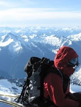
The summit provided some great views and we enjoyed the sun’s heating rays and slight breeze. Although I was really sad when Andreas pointed out the clearcutting on the neighboring peaks.


This mountain reminds me of those bald cats/dogs that you think are totally gross but you can’t stop staring at.


Not long after we got to the summit the hills rang with the devilish motor sounds of snowmobilers. We were totally bummed out – our solitude was ruined. Fortuantely we couldn’t see these snowmobilers from our spot on the summit, but I did not-so-secretly wish they’d fall in Annette Lake.


The view from the summit after the snowmbilers had full “high walling” the ridge. (Enlarge the photo to really see how high on the wall they got)


On the way down we decided to avoid the ridge, bowl, gulley, ridge route and went down the other side of the mountain towards Annette Lake. We figured we’d hit the summer time trail eventually. This was a slight mistake on our part—we should have either gone back the way we came, or traversed further to the right instead of heading more straight towards the lake. Further to the right would have given us some nice downsteps but we also would have avoided any runouts to the Lake and ended up in a gulley which would have guaranteed our safe arrival back to the main trail.


Annette Lake from the summit


Either way we were able to get really fun lofty steps down, and seemed to be down the hill in no time. And by in no time I really mean, once we got most the way down, we had to walk precariously through the steep woods, avoiding streams that were only covered in inches of snow/ice, and navigating through a lot of brush, hoping we didn’t find any runouts to strong for us to cross.


Holy crap we were just up there?!


It was getting late (since we had spent at the very least an hour, probably closer to two, on the summit) so we didn’t stop much at Annette Lake, we were still a few miles from the car.

On the way back I couldn’t help but comment, multiple times, how insane it was that 4 feet of snow had melted in the month since I had visited with BoeAlps.


When we crossed this bridge the first time (with BoeAlps) we could see the top of the railing a few inches below the snow we were walking on.


We were about to the car when we met a family who asked us “how much further to the lake?” We hated to tell them to turn around, but we assured them there was no way they’d make it to the Lake and back before dark. They didn’t seem to have any water or food on them (not to mention head lamps!) and we highly discouraged them from continuing. Fortunately they heeded our warning. We saw their car in the lot, they were from California.

We had a few lessons learned this trip, such as bringing more gear than you see your peers have (especially if those peers are in jeans) is totally reasonable. We also learned that it’s always OK to turn back to try a new path. There were a few points where although it would have lost us time, it would have been much safer had we gone back to our original path, held our heads in shame, and tried a new route. We vowed not to be “those guys” again.


Summit panorama! (click the photo to enlarge it)


You can view more photos here: http://www.flickr.com/photos/7372593@N02/sets/72157619126691136/

Saturday, May 23, 2009

Mt Si -- ChrisGaye and Kate

Where: Mount Si, North Bend, WA
When: Saturday, May 23rd, 2009
With: ChrisGaye + Kate
Goal: Hike!


An intense staredown between Kate and Chris


Chris and Kate just made their way from the East Coast and after many days in a car wanted to stretch their legs. I suggested the slightly rugged (steep, not really hard otherwise) Mount Si as our destination for the day. I warned them that it was a steep hike and they were excited for a challenge. Mount Si is a 4,167ft climb in 4 miles (3,900ft without the haystack).

Chris led a very fast pace the entire first half, and I took over a slightly slower pace for the second half (with a heed that the next section would be steeper and to help keep a constant pace).

Overall our pace led us to pass at least 11 other groups mid-walk (usually 1-3 hikers per group) and countless others who were resting on the sidelines as we passed by. This total did not include people we passed multiple times. There was one guy and his dog (a chocolate lab!) who passed us on the way up but that was it. Anybody else that passed us, we passed again before the summit.

We made it to the top in exactly 2 hours. Well, the top of Mt Si not including its infamous haystack which is a short but steep scramble. We had lunch and enjoyed the view. Chris is my new roommate (also from Vermont!) and the (albeit hazy) view made him confirm that Seattle was a great move—just one full day in.

We could see Rainier and could faintly see the sound but we couldn’t see the Olympics nor could we see the city (Bellevue or Seattle).

After lunch we walked to the far side of the haystack—it being the only accessible side unless you’re planning on rock climbing and placing your own protection.


The scramble can look daunting, more daunting than this picture leads on


About halfway up the scramble Chris decided the top view wasn’t worth the potential dangers and went back down. Kate and I continued to the top. This was my third time at Mt Si but only the first time I hit the true summit. All the other times it was covered in snow and since I didn’t know what terrain was under the snow I didn’t want to continue. That and the fact that there were no tracks leading to the top and I was alone; it would have been a dangerous idea to continue.


We saw an eagle while we were on the summit!


Kate enjoying the summit view


After some summit photos we climbed down—which proved to be a little harder than the climb up but neither proved too problematic, even with Kate’s Converse sneakers.

The walk down was, as always, a little rough on the knees but passed by quick enough. Before we knew it we were back in the cars and headed back home. Well, Chris who was astounded seeing the Twin Peaks diner requested a stop. Kate ordered the infamous Cherry Pie, I had a Vanilla Shake and Chris went with the safe vegan option of an Italian Soda.

Wednesday, May 20, 2009

Wilderness Peak -- Solo

Where: Wilderness Peak, RT900, WA
When: Wednesday, May 20th, 2009
With: Solo
Goal: Beat personal record of time it takes to summit

Wilderness Peak is the closest hike to my Boeing Job in Renton. It’s a short hike, about 4 miles roundtrip, but it has a pretty nice elevation gain (that I am unsure of at the moment).

After slugging on my new Black Diamond pack, within it a ample water and summit raspberries (that I forgot about), and grabbing my trekking poles from their permanent home in the back of my car I was off on the trail.


Not king slug, but another slug seen on the way down


At the beginning of the trail I saw a king slug (not official name, but what I’ve named him). He was at least 5” large and his coloring reminded me of a leopard. I really wanted to take his picture but that would have slowed my time down! [I was super bummed on the way down when he was gone from the trail]. After leaving the slug I thought that he would probably make an entire meal! [If you were desperate].

I kept a solid pace the entire way; breathing hard and working hard was the motto of the hike.

I reached the peak in 36 minutes and met an older couple who were working on identifying the bird calls of the surrounding birds. I am always disappointed at this Peak because there is NO VIEW whatsoever. A log book + no view = unacceptable.

I flipped through the logbook, looking for older entires to see how much I had beat my old time by but it had been recently updated and I couldn’t find any previous times. BUT I did find an entry from “Alison” who has the exact same handwriting as I do. I honestly did a double take, and had to re-read the entry to make sure it wasn’t really mine. I don’t know where one of the references she made was (which means it can't be me!), but she had exactly my same vernacular too (using “stoked” to talk about beating her personal record up the hill), and the handwriting was uncanny.


Who knew these guys didn't just live on the beach


The way down was uneventful other than my realization that there can be 2” snails on the trail! I had no idea snails this large could live on trails (in VT we have super small snails, smaller than your fingernail but that's it). Also, there were a ton of other slugs. Mostly this black slug that just reminded me of a bloated leech and this other brown slug that had a really weird texture to half of his body (crappy photo above... the camera on my phone was not being nice).

After the hike I ran home to grab a quick bite to eat (including some strawberry rhubarb pie!) and then went to Alpine Class.

Monday, May 18, 2009

Crevasse Rescue -- BoeAlps

Where: Nisqually Glacier, Rainier NP
When: Sunday, May 17th, 2009
With: BoeAlps BCC Team 7
Goal: Practice Crevasse Rescue


Click to make the photo larger, this was taken while I had "fallen" into the crevasse


5:30 rang in the ears of Team 7 holding up in Whittaker’s Bunkhouse. Side Note: warmer nights may not be the best time to book an attic room!

Most of us grabbed breakfast as we slipped on different base layers. It was already pretty warm outside forecasting a brutally hot day on the reflective glacier.

We arrived at Paradise (the main Rainier are with the Ranger station, and start to many of the trails going around the park and the most popular routes to the summit of Rainier.

Shortly after starting the trail towards Muir (Rainier basecamp) we were instructed to put on our crampons. They weren’t necessary for this specific part of the trail but it would act as a practice to prepare for our graduation climb coming up shortly—where crampons would most likely be needed.

There were over 80 students and instructors on the Nisqually Glacier; to others it probably looked like a rouge army taking over. Our destination was a large open crevasse. We turned off the beaten Muir path and soon enough we were able to take off the crampons and trade it in for being tied onto a rope with another student and instructor.


When you’re roped up, there’s about 20m between each climber. It makes everything take longer. You can also see a bunch of crevasses on the right.


Unfortunately, before we were able to rid ourselves of the crampons Todd gashed his gaiters, a $50 bumout. We tied into the rope in case a member fell through a snowbridge and into a crevasse or in case one of us found a new crevasse in general. The hope is that only one person would fall and the other two people tied to the same rope would be able to arrest, and a) stop the fall b) prevent more people from falling into the crevasse and c) enable the rest of the team to assist in getting the fallen climber out.

Fortunately, none of us fell into any unknown crevasse, on accident. The goal of the day was not only to practice crampon and rope travel but also to perform a crevasse rescue. Each of us played a key role in simulating a rescue. For safety we added a belayer who would have an extra rope tied to the person in the crevasse in case the rescue team was unable to perform the rescue properly.


This is what the fallen climber see’s. The ropes wear away at the lip of the creavase which make getting out harder. Also, normally there would only be one rope—the one attached to your other partners.


A student would be lowered into the crevasse with 2 ropes on them. One being the safety belay (not present in “real life” rescue) and the other rope would be the glacier travel rope. The student could try to prussic up the rope (climbing up the rope with the aid of smaller ropes which would be attached to the harness). This would be the ‘best case’ scenario—the team was able to arrest and the fallen climber would be able to get themselves out of the crevasse without additional help.


The sides of the crevasse wall were covered just solid ice. It would be impossible to try and claw your way up.


Since the ‘best case’ scenario is not guaranteed we did not allow the climber to get to the top.


Ken is in the middle of the rope and has arrested to hold the fallen climber.


Initially, the two other climbers on the rope would arrest with their ice axes. After this was done, the climber the furthest away would come down to start setting up the pulley system (once they confirmed that the middle climber was able to keep the arrest with the weight of the fallen climber).


Ryan is on the top of the rope, he’ll arrest too, and then come down to the middle arrested climber to help set up the pulley system. Eveleyn is the safety belayer (and would not be present in a real rescue).


The top climber would then set up two anchors to take the weight of the fallen climber and to ensure the arrested climber did not slip.


Todd has “fallen” into the crevasse! You can see on the bottom of his rope there are some prussic knots tied. This rope is attached to his waist and feet. In a combination of sitting and standing, and moving your prussic knots up, you can slowly get yourself out of the crevasse.


Then, as a team, the two climbers would continue the rescue, setting up the pulley system. Even with a z-pulley system (a mechanical rescue using 2 pulleys) the fallen climber was still hard to pick up.


Even though you may think you're at the bottom of a crevasse, you probably aren't. The bottom could break away at any moment!


Before we knew it we had our rescue down to 20 minutes (up from about an hour). Sadly, this is not a real statistic for our subsequent rescues all had the anchors placed. One would probably be lucky to set up the z-pulley system in under an hour in real life. The group can just hope that if a member is unfortunate enough to fall into a crevasse, the fallen climber is not hurt so badly that they are unable to prussic back up.


Click the photo for a fullscreen size


Overall, the crevasse rescue outing made taking the BCC class completely worth it. The real-life experience of being lowered into a crevasse and performing rescue really makes you appreciate the dangers that are out there. I hope I never have to perform such, but if I must, I feel I’ll be much more prepared.

In terms of the hike itself, I actually felt the worst on this outing and was slower than ever before (ALMOST becoming the slowest in the group). I am positive it was because of the beating sun (and maybe a tiny bit from the 32 mile bike ride the day before). My body doesn’t regulate heat very well and I was sweating moments after leaving the parking lot, when I was only in my base layer. At the end of the day, when the sun wasn’t as intense my energy picked up, and I even led the team home up the steepest hill.

Saturday, May 16, 2009

Bakery Bike -- Andreas

Where: West Seattle to Magnolia and back
When: Saturday May 16th, 2009
With: Andreas
Goal: Bike to Magnolia and celebrate with cinnamon buns


We rode A to B to C to B, almost 32 miles


Since I haven’t biked in awhile I decided the gorgeous-weather-predicted-Saturday would be a prime time to get out and ride.

I like goals. I decided the biking goal would be a bakery that my co-worker Phil sometimes brings in decadent treats from. I didn’t really look at the miles, but I’m in Seattle, it’s in Seattle, so it seemed like a reasonable ride.

When I first mentioned the outing to Andreas he seemed to think it was a lame ride in that it would surely be under 50 miles, and who knows if there would even be many hills in between. I told him that I am a newbie biker, so I needed an easy first ride and he conceded to the plan.

As you can see in the picture above, a round-about way was taken. We started at my house, stopped at Andreas’ (though in retrospect I’m not sure why), and then took the scenic Alki Beach tour, and peddled up the “coast” to Magnolia (subsidiary of Seattle) where the bakery was located.

By mile 15 (it was 18 miles to the bakery) our back-ends were in constant reminder that we had not been bike riding in quite awhile.

Less than a quarter of a mile left to the bakery and we were met with some pretty intense uphill. It was nice knowing that we’d be making the cinnamon bun worth it! Andreas sped ahead and killed the uphill while I took a water break at a crossroad—but made it without having to walk my bike and feeling totally inadequate.

The bakery was out of cinnamon buns (we’ll have to get up and biking a decent hour next time), but we enjoyed some quiche (lunch) and a sticky bun (dessert) instead.

The ride back was pleasant, other than a constant dodging of people, and we were home (at Andreas’) in what seemed like no time. After speeding back home (in the car, to my house) and in less than 30 minutes I packed all the gear necessary for my Crevasse Rescue outing and was out the door to meet the team, to once again stay at Whittaker’s Bunkhouse to avoid a 3am wake-up call.

All in all, I didn’t expect the ride to the bakery to be 31.9 miles, but it was a really fun ride nonetheless. Hopefully this will inspire me to ride my bike more often!

Friday, May 15, 2009

Little Si -- Andreas

Where: Little Si, North Bend, WA
When: Friday May 15th, 2009
With: Andreas
Goal: Get a small hike in so we still had time to work

[Andreas has photos, I didn’t bring my camera, although I did bring my brand new Black Diamond backpack—an early birthday present!]

It was a prime Friday with the sun beckoning one outdoors. I’ve found you get much less work accomplished when you’re staring out the window drooling about the outdoors, versus working later at night when its dark and you forget the wilderness (slightly).

Andreas and I are also a bad influence on eachother when it comes to being outdoors.

I suggested a small hike, so we’d have plenty of time to get back to work. We settled on Little Si since it was close to Seattle and neither of us had done it. We knew Mt Si was a good workout and we figured Little Si would be similar.

Little Si is a 5 mile hike. As www.mountsi.com says (reading in retrospect): Hard-core hikers might think of Little Si as a desperation hike for the rare occasions …. They were right.

We quickly summitted and were left wanting more. We were rather confused. We had heard Little Si was a nice hike. Instead we felt cheated, a nice hike for your grandmother maybe. We wished there was a bridge to Mount Si so we could summit that. It was decided that going to the bottom of Little Si to then climb Mount Si would be a little excessive, and that it would ruin our idea of a short hike and we wouldn't be able to get back to work.

We collected our sad hearts and stopped at an ice cream joint on the way home. Sadly, we didn’t even feel justified in our ice cream earnings. Fortunately, the ice cream tasted satisfying nonetheless.

Monday, May 11, 2009

Tatoosh Wilderness -- BoeAlps

Where: Tatoosh Wilderness
When: Sunday May 10th, 2009
With: BoeAlps BCC Team 7
Goals: Peak-Bagging in a safe manor
Peaks: The Castle (6640'), Pinnacle (6562'), Plummer (6370'), Denman (6006')


Our route--the dotted line is the Saffron-Direct route taken.


The team arrived at the Longmire parking lot in the Rainier National Park at 6:30am. After a bit of waiting for our last team member to show up we headed to the second parking lot, sans team member, to the Narada Falls lot at about 4600ft. Once our shoes, gators, helmets and essential gear was dawned we headed to an extremely steep pitch to a different switchback of the road. Note: The road is closed for vehicles, so we climbed straight up the switchback. As we were walking to this “trail head” our last team member showed up.

After the straight up steps we walked along the road for about 1.5 miles before stepping up a large bank heading to our destination. Team Double Black had kicked some great steps that we followed all the way to Castle (another 1-1.5 miles). We were thankful of the great steps—the last time we tried to use their steps they had ruined them by downstepping in their up steps and they were basically worthless.

By 10:45 we were at Castle, coming from the south east face. We really pulled out some efficiency in setting up the ropes. I attribute that to help from Mike Z (a guest instructor) who set up the ropes and rappel station while Stefan manned the climbing belay section. The way up was a low class 5 rock but for safety and experience we had a belay for this section.


Mike climbing the route and placeing pro


Everybody climbed the peak with speed and we had rappelled down and were done with the peak in record time.

By the time we were all down the first peak, another BoeAlps team had just gotten to Pinnacle Peak. We circled around Castle and approached Pinnacle from the south side, up an easy gully.


View of The Castle


View of Pinaccle


Since the other team was working on Pinnacle we decided to move on and tag Plummer Peak. It is a little less than a mile away from Castle and was a pretty simple ridge walk to get there. We approached the western portion of the south face and used another teams traversal steps until we got to the steep section. Then we made our own steps to the summit with Mike and Kyle in the lead. As we approached Plummer we saw an epic cornice. We made sure to stay far away from the edge on that summit!


Watch out for the cornice! This is the summit of Plummer


When we summited we once again pulled out the ample summit treats. It was Matt’s birthday so I stuck my emergency candle in my group of peanutbutter/chocolate bars so we could truly celebrate his birthday.


Emergency candle birthday!


At the summit of Plummer we pulled a quick debate of going back to Pinnacle or heading to Denman. Denman was downhill, which meant we’d have to go back up to get to Pinnacle, and we didn’t want to kill ourselves. Alas, before we could talk it through, some of the group was already on their way to Denman. By 1:08 we were at Denman, after Ryan kicked our steps to the summit.


Summit of Denman


We only stayed at Denman enough for another cookie (or two!) and then were headed back to Pinnacle. No team had gone this way, so Leanard, myself, and Matt kicked steps up the traverse back. Right after I stepped out and Matt took over, there was a slight discussion of taking the high road or the low road. Matt started taking the high road but the low road was much more direct and less work, so some of the team started in that direction. Moments later, the high roaders kicked some snow and soon enough our team had created an avalanche!


Avalanche from afar...that we created


All day we had seen huge pinwheels where the snow had started out as a tiny ball on the top of the mountain, but had turned to tractor tires in no time.

When we got to Pinnacle, the other team had barely cleared out—it was good that we had done the extra two peaks! Once again we initiated a Saffron-Direct approach and all started scrambling up the low 5 pitch. Our line of scramblers was much faster than the other team, who climbed it one at a time and used a prussic to go up the rope. There’s always a trade-off of time and safety. Our team is pretty confident in our climbing abilities so we didn’t feel it was necessary to be tied to a rope.

Once we got to the summit we noticed the clouds were getting even darker (since we left Plummer they were trying to take over, unsuccessfully). Scared of rain we scooted off the summit, practiced an arm rappel down a small section of rope and then half of us rappelled down a vertical spot of rock and the other half did a longer arm rappel down the up-hill route.


Ken doing an arm rappel


The other team was nearing the Castle summit at this point, using the ropes we had set up. (We had just used the ropes they set up).

On the way home we were able to use our favorite downhill technique—glissading. Glissading is where you do a controlled slide down the mountain, and save tons of time and energy! Evelyne is by far our fastest glissader, she knows exactly how to balance her weight to create the least drag, and flies down the mountain. We made our way back towards Reflection Lake (and the road we came on), following a north-east heading.


Ken Glissading


We got to the parking lot at exactly 5pm (the goal time) and not 2 minutes after our arrival it started to rain. Fortunately, it was only a light, intermittent rain, so the other team still on the mountain didn’t get drenched. They came down about an hour later. Then we were off to a great restaurant whose name I have forgotten, but it’s in a red building, and was located a few miles outside of the park, and there were tons of cars parked on the side of the road by it! The homemade blackberry vinaigrette dressing and blackberry butter for the bread is absolutely fantastic and definitely recommended.

Overall the Tatoosh Wilderness was a ton of fun. I think I want to go back in the summer and do all 12 peaks as a long weekend camping trip!


Summit of The Castle

Exit 38 / Gun Show -- BoeAlps (makeup!)

Where: North Bend / Exit 38 / Gun Show Area
When: Saturday May 9th, 2009
With: Half of BoeAlps BCC Team 7
Goals: Have fun climbing! And for me to make up Levenworth Skillset.


Photo of the 40m pitch we climbed at the end of the day.

We met at one of the many trailheads off Exit 38 at 9am (yes, we got to sleep in!). We stocked up on rope and protection (in the end I think we only used quickdraws) and headed down the trail to the official rock climbing areas with instructors Stefan and Charlie.

The parking lot wasn’t full yet, even though the day was already super sunny; we were stoked. It was about a 25 minute hike to the first rocks. Apparently climbers are a lazy bunch for we only passed 3 other people climbing.

I was able to practice some key skills such as, belaying without a belay device, tying off a fallen climber and rappelling past a knot in the rope (that I was currently rappelling on).

While I practiced these skills Matt and Ryan (who came along for fun) went up a 5.7 pitch that Stefan lead. I joined them after my skillset and climbed the fun juggy route as well, as Lingyung went over some key skills with the instructors.


A key skill is knowing how to take care of the rope.

Then we headed to the Gun Show area to a route called Endless Bliss. Stefan led the route as Ryan belayed. The route is a 40m 1.5 pitch 5.10a route (although the rating is questionable since there were some added hand holds…not sure if that was before/after the rating was stated).

Stefan set up the top of the route so it was simple sport climbing for the rest of us. Ryan went first, and was belayed by Stefan from the hanging belay at the top of the first pitch. Ryan raced up the route and stayed at the hanging belay, and belayed Matt up.

Matt found the route a little tricky. It’s an odd route, for there are barely any hand holds and it really forces you to trust your feet. This trust is in your foot sticking to an edge maybe half an inch big.


Matt stretched out on the route while Stefan and Ryan are at the hanging belay station.

Matt switched places with Ryan, and Ryan was able to belay down. Then it was my turn to climb the pitch. I was really excited to be climbing outdoors. It’s a ton different than gym climbing, and I like it a lot more. You’re doing all the work, finding out where each handhold is (versus following a color-coded route) and you really have to use your body imaginatively (while still staying in balance!) to reach the next hold or just to rely on your current footing.

The hardest part of the route for me was actually trying to get my feet in different resting positions. Since I’m shorter than the average person, I am always on my tip toes trying to reach the next hold. I think I’ll have to look into some calf and foot stretches to do before/after climbing and maybe some exercises to improve the muscles in this area!


The top of the route!

Once we all got back down (for times sake, I went up then down, without getting my shot at the hanging belay, and then Stefan belayed Matt down, and then came down himself), we decided to head home.


The rope that was about to belay me down to the solid ground.

When we got to the parking lot we were shocked not only to see an overfilled lot, but also cars lining the road. We didn’t actually see that many more climbers ourselves, but we did go to the “far” climbing area. There are some areas closer to the road (less than a 20 minute walk) that are much more popular.

Matt, Ryan, and I drove south to Whittaker’s bunkhouse where we spent the night to avoid a 3am wakeup call and a 2+ hour drive in the next morning for our Tatoosh adventure.

We also ate at the Higherlander bar next door to the lodge, and vowed never to eat there again. Worst service ever and typical sub-par bar food.